Tagged: Google Earth KML files
- This topic has 14 replies, 8 voices, and was last updated 5 years, 2 months ago by
 Steve Rohrbaugh.
-
AuthorPosts
-
February 26, 2021 at 7:14 PM #11416
 John Benario General Member
I flew (737) into Ontario on the Ziggy arrival a couple of days ago. We passed directly above Crestline launch at 8400 MSL and we could have been lower if we weren’t following a UPS DC-10 and had to maintain wake turbulence separation. Passenger traffic is picking up and Ontario was one of the fastest growing stations before Covid hit which will mean more flights into Ontario.
Keep in mind you may be sharing the airspace with a 737 (or bigger) above 8000 if you are in the vicinity of Crestline.
February 27, 2021 at 8:04 AM #11418John Benario General Member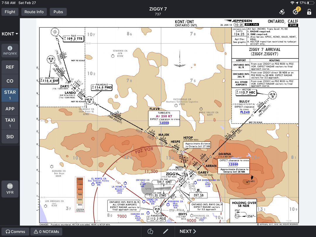 February 27, 2021 at 9:32 AM #11420
 Jonathan Dietch Premium Member
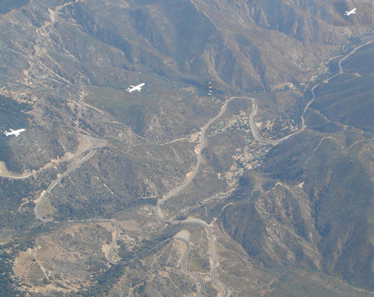
Sort of like these two encounters on the same day….
February 27, 2021 at 4:20 PM #11421 David Webb General Member
A wise man in orange once told me “don’t linger at 8k over Crestline.” Looks like that advice holds water.
February 27, 2021 at 6:24 PM #11426 Mark Hoffmann Premium Member
Scare liner >> I’m the 4 small white dots :) Dusty took 4 pics and stitched them together somehow. I think he was at around 12K and climbing. I was climbing through 10.5K I guess.. I think we topped out around 12.5K… looks like the airliner adjusted its heading just a bit…
 March 1, 2021 at 8:58 PM #11451John Benario General Member
Thanks, Mitch, but not new. My goal as safety director is to help the club operate as safely as possible. There are always new pilots joining us who may not have the knowledge that you have as a 30 year HG pilot, or me as an airline pilot and a 35 year HG pilot. These new pilots probably aren’t aware that there is a terminal arrival route directly over Crestline at altitudes that are not uncommon for us to reach. It it those pilots I am trying to reach and provide useful information to.
You have many years of valuable experience. I look forward to your help in keeping our club members safe.
March 2, 2021 at 8:12 AM #11463Mario Miralles
Premium MemberJohn, thanks for sharing your personal experience and thanks for volunteering to be the safety director. There are a number of times each year that I have to let a newbie or visiting pilot know about this, so it is relevant and helpful, especially with the traffic increasing and the consequences of a midair.
Mitch, saying that John is misinformed, bragging about his job or pretending superior knowledge says more about you than anything based on reality. I would suggest not polluting this forum anymore or learn to delete personal attacks before submitting your posts, because what little useful knowledge or information you add gets lost in your delivery.
March 3, 2021 at 7:14 AM #11487Heres a kmz file. actual paths curve through the waypoints.
March 3, 2021 at 9:49 AM #11489John Benario General MemberDan, what do I need for my Mac to look at the KMZ file?
March 3, 2021 at 10:39 AM #11492David Webb General MemberThere are other methods, but one simple way is to download Google Earth:
https://www.google.com/earth/versions/
You can import kmz files directly into that.
March 3, 2021 at 4:56 PM #11504John Benario General MemberJonathon pointed out something to add. The airliners are not guaranteed to be on that particular path. Sometimes we are vectored off path for spacing reasons, or more frequently, once you are cleared for a visual approach you can do whatever you want. Come down quickly, veer away from the Ontario if you need more time to come down, turn directly toward Ontario if you are coming down fast enough.
In Mark’s picture the airplane veering left is probably to give themselves more time to come down.
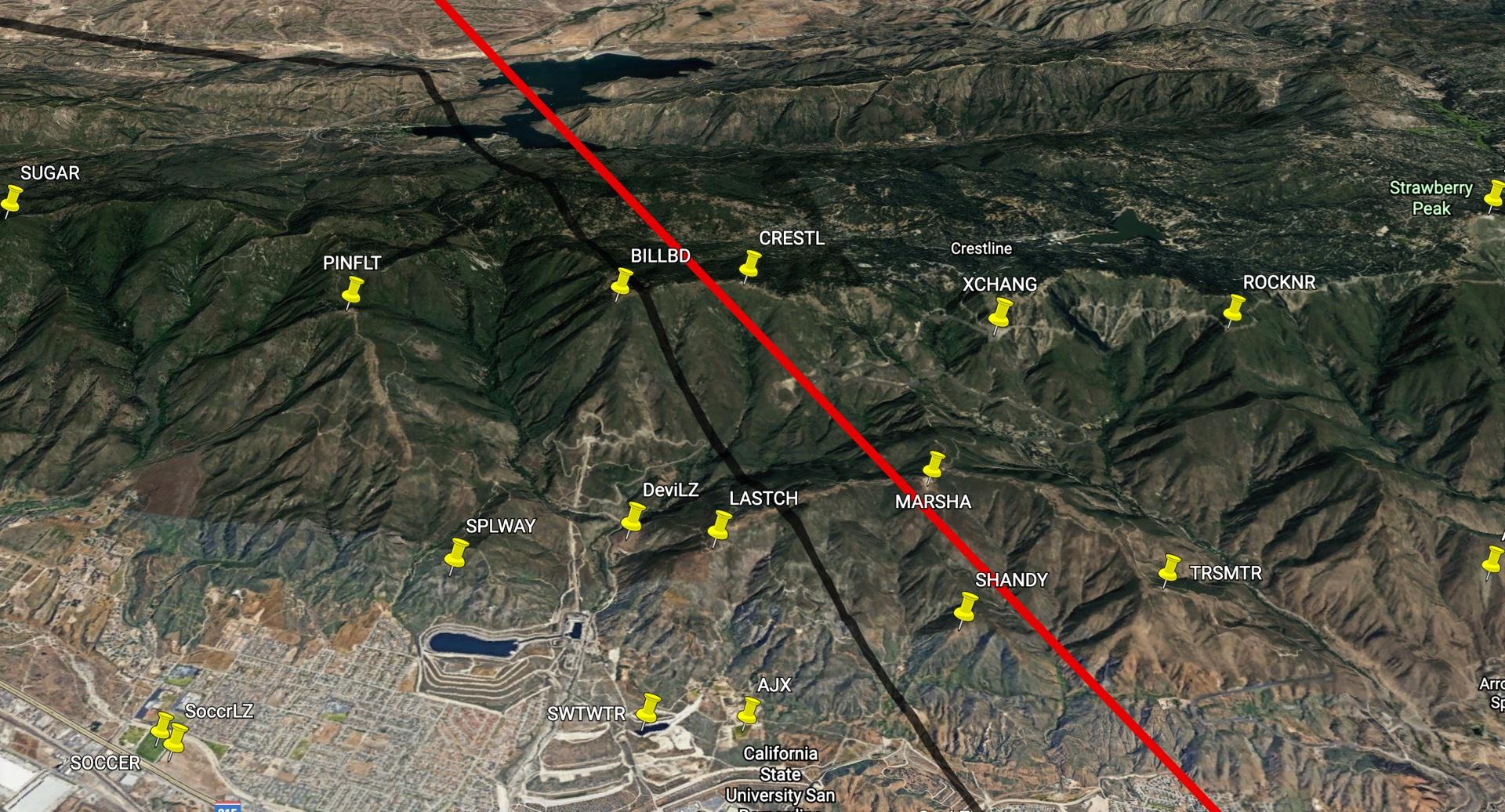
March 4, 2021 at 8:29 AM #11511David Webb General MemberUsing the KMZ file from Dan, in addition to the master KMZ with all of the local waypoints, here’s the path of the Ziggy. Notice the shadow on the ground – looks like it goes right between Billboard and Crestline launch.
 March 4, 2021 at 6:20 PM #11519John Benario General Member
The arrival is called an RNAV arrival. We have to use RNAV to follow it. RNAV is a combination of GPS and INS, so they can check on each other. The path accuracy of the RNAV system and the autopilot is about .05 (!) nautical miles. Yes, it is that good. Most pilots are not going to be hand flying on the arrival, so the path accuracy is basically dead on. However, once cleared for a visual, then maybe hand flying, maybe landing gear down to come down faster, turn away before turning back toward ONT as in Mark’s picture. I think you can assume no one is going to be turning toward ONT off the STAR because it is hard to come down fast enough if you shorten the path.
ATC can turn us east at any time for spacing.
The most objective question I think from Gary above is where do they clear us for a visual? Any time after the dogleg at hitop I think is realistic answer. Since the weather is good most days, it never rains in southern Ca…., most approaches are visuals, that is why the airplanes are below the altitudes and MEAs specified on the STAR.
I think David’s path is right on. since I was sitting on the left, and I could look down and see launch, that means the airplane was in between BB and CL.
March 5, 2021 at 7:44 AM #11528Alan Crouse
Premium MemberI’ve been back in the passenger area on several late-day flights from OAK to ONT that seemed to fly a diagonal route down the Cajon Pass. We were looking up at the ridgeline… That approach seemed to happen more frequently on north wind days, which always struck me as odd…
March 7, 2021 at 1:32 PM #11584getting & running Google Earth desktop would be best for that and making great Site Maps. Although the web version would work.
Windows & Mac versions are available: https://www.google.com/earth/versions/
-
AuthorPosts
- You must be logged in to reply to this topic.