Home › Forums › Weather & Weather Stations › RASP & Windgram Upgrades
- This topic has 24 replies, 8 voices, and was last updated 4 years, 9 months ago by
Justin Watts.
-
AuthorPosts
-
March 18, 2021 at 9:00 PM #11706
Alan Crouse
Premium MemberVrezh:
Glad to hear from you. I see exactly what you mean. I’ve reached out to the network of experts to see what options exist…
Thank you,
Alan
March 18, 2021 at 10:29 PM #11707 Jonathan Dietch Premium Member
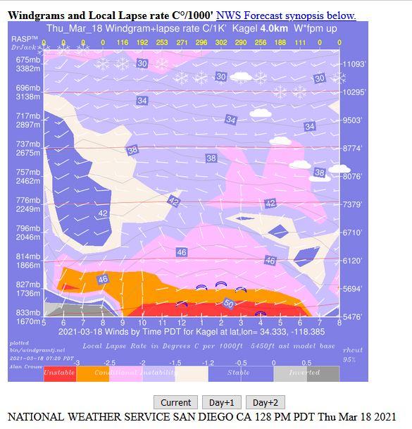
Hi Alan,
I cannot tell whether you understood or responded to Vrezh’s concern that the Windgram display for Kagel Mtn is truncated 2,050′ above Kagel launch altitude. Please see the attached screen print which should have it’s Y axis more than 2,000′ lower.
Thanks for all you do!
Jonathan
 March 22, 2021 at 7:46 AM #11723Premium Member
I made some changes yesterday that are reflected in today’s Windgrams. We now have data well below Kagel’s peak. It required some modification of the underlying model and removal of the SRTM elevation data, so a non-trivial issue. Still in communication with the gurus in the Netherlands to try and get the SRTM data working.
March 22, 2021 at 12:16 PM #11724The scales seem to be messed up on BLtop and BLdepth too. I do like the contrast in positive and negative values in the convergence graphic. Thank You Alan.
March 22, 2021 at 2:02 PM #11730Premium MemberI see what you mean. The actual point values seem correct (available from right click), but the scale tops out way too early and a lot of area is at the top color. Probably a holdover from the work done in Europe. The data is converted, but the scaling itself needs to change. Having a top of 3000 is ok when it is meters, but not when it’s feet…
March 23, 2021 at 6:22 PM #11735Premium MemberToday I think we just about figured out the issue with the SRTM data. Waiting on confirmation from the Netherlands.
Also, the Meteograms are now available from the Windgram site. Radio button to switch between the two formats.
March 25, 2021 at 9:28 PM #11745Premium Member“The scales seem to be messed up on BLtop and BLdepth too.” The problem turned out to be that some of the scales were pre-set to specific values. I’ve changed them to scale according to the output values. If some of them look better the other way, please let me know. Easy to switch now that the reason has been identified.
September 22, 2021 at 9:01 PM #13778Hey Alan!
My name is Justin and I am starting to help out with https://canadarasp.com/windgrams
Read though this thread and love what you have done! Is your work by change open-source or available to be integrated by other gliding clubs? Let me know if there is a better venue to chat more in depth!
September 23, 2021 at 8:17 AM #13779Premium MemberJustin:
All the RASP and Windgram/Meteogram stuff is open source and available. There is a small, but dedicated, group of developers around the globe who share what they create. Hit me up directly at ac_soaring@yahoo.com and take a look at Dr Jack’s RASP forum RASP Forum: for users of RASP predictions (drjack.info)
Alan
September 23, 2021 at 8:28 AM #13780Holy wowza! This is awesome. So glad to not be alone in the fray. Will be in touch in both places.
-
AuthorPosts
- You must be logged in to reply to this topic.